 |
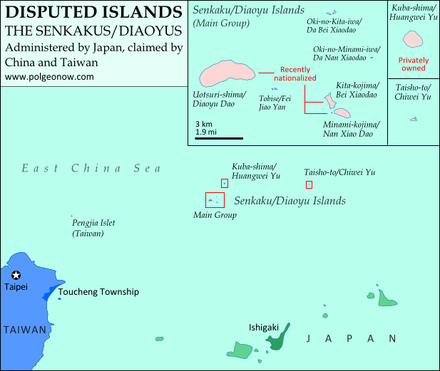
Map of the disputed Senkaku/Diaoyu Islands (by Evan Centanni). Click to view at full size.
|
The Senkaku/Diaoyu Islands
A recent feature on Political Geography Now introduced the history and status of the Senkaku/Diaoyu Islands, a disputed territory controlled by Japan but claimed by China and Taiwan. The article included an original map which showed the isles' configuration and precise location within the East China Sea (click on the map at right to see it at full size). But if you're like me, you may be wondering "just how small are these islands, and what do they really look like?"

Chinese (China): Diàoyúdǎo (钓鱼岛)
Chinese (Taiwan): Diàoyútái (釣魚臺)
Area: 4.32 km2 (1.67 mi2)
Highest Point: 383 m (1,257 ft.)
The largest isle in the disputed archipelago, Uotsori has been a center of historical activity in the Senkaku/Diaoyu Islands. It was the site of a Japanese fish-processing plant from about 1900-1940, when it hosted 200 workers. Since then it has been uninhabited, but was visited by a Japanese academic-governmental delegation for four weeks in 1979.
The island was one of four sold to the Kurihara family in the 1970s. The Japanese government rented the island from 2002, before finally buying it from the family last year. Though the island is no longer inhabited by humans, it is home to a population of domestic goats and albatross, as well as a species of mole found nowhere else on earth. Once called "Peaks Island" by the British, the current name means "Fishing Island" in both Japanese and Chinese (the name used by Taiwan is literally "Fishing Platform"). (photo source)

Chinese: Běi Xiǎodǎo (北小島/北小岛)
Area: 0.33 km2 (0.13 mi2)
Highest Point: 135 m (443 ft.)
Japanese: Minami-kojima (南小島)
Chinese: Nán Xiǎodǎo (南小島/南小岛)
Area: 0.46 km2 (0.18 mi2)
Highest Point: 149 m (489 ft.)
These are the only other major islands in the main cluster of the Senkakus. Like Uotsuri, they were sold to the Kurihara family in the 1970s, rented by the Japanese government from 2002, and bought by the government in 2012. The islands' names are written the same in both Japanese and Chinese, and mean "Northern Little Island" and "Southern Little Island" respectively. (photo source)

Chinese (China): Běiyǔ (北屿)
Chinese (Taiwan): Chōng Běiyán (沖北岩)
Other Chinese Names: Dà Běi Xiǎodǎo (大北小島), Běiyán (北岩)
Area: 0.02 km2 (0.01 mi2)
Highest Point: 28 m (92 ft.)
This is actually a small group of islets located in the northeast of the Senkaku Islands' main cluster. It consists mainly of barren rocks, and has apparently never been privately owned. The Japanese and various Chinese names are variations on "Northern Islet" or "Northern Rock"; yet one name, Dà Běi Xiǎodǎo, means "Big Northern Little Island", seeming ironically to imply that it outsizes the much larger Běi Xiǎodǎo (Kita-kojima). (photo source)

Chinese (China): Nányǔ (南屿)
Chinese (Taiwan): Chōng Nányán (沖南岩)
Other Chinese Names: Nán Běi Xiǎodǎo (大南小島), Nányán (南岩)
Area: 0.005 km2 (0.002 mi2)
Highest Point: 13 m (43 ft.)
Located at the eastern edge of the main cluster of the Senkaku Islands, this another barren rock which has apparently never been privately owned. Its names in Japanese and Chinese present it as the southern counterpart to Oki-no-Kita-iwa. (photo source)

Chinese (China): Fēiyǔ (飞屿)
Chinese (Taiwan): Fēilài (飛瀨)
Other Chinese Names: Fēiyán (飛岩), Fēijiāoyán (飛礁岩)
Area: 0.0008 km2 (0.0003 mi2)
Highest Point: 2 m (7 ft.)
Tobise is a cluster of rocks located just southeast of Uotsuri, the biggest island of the Senkakus. Although the area of shallow water surrounding it gives it a larger profile on some maps, according to the Taiwan government's measurements it is the smallest of the eight major named isles of the Senkaku/Diaoyu Islands. It is also the lowest, protruding little farther above the water than the height of a person. Its Japanese and Chinese names all translate to something like "flying shoals" or "flying reef". (photo source)

Chinese: Huángwěiyǔ (黃尾嶼/黄尾屿)
Area: 1.08 km2 (0.42 mi2)
Highest Point: 117 m (384 ft.) Kuba is the second largest of the Senkaku Islands, located to the north of the main cluster. In the 1970s, it was sold to the Kurihara family along with the three major islands of the main group, but was owned by the sister of the man who the other three belonged to. Today it is still owned by the family, but rented by Japan's Ministry of Defense. The Japanese in turn allow the U.S. military to use it as a practice bombing range for aircraft. "Kuba" is a Japanese surname, and the Chinese name means "Yellow-tail Islet". (photo source)

Chinese: Chìwěiyǔ (赤尾嶼/赤尾屿)
Area: 0.06 km2 (0.02 mi2)
Highest Point: 75 m (246 ft.)
Taisho is the most distant of the Senkaku/Diaoyu Islands, located over 100 km (60 mi) to the east of the main group. A relatively high island for its size, it has been continuously owned by the Japanese government since Japan formally took possession of the islands in 1895. In Japanese, the island is probably named after Emperor Taishō, the Emperor of Japan at the time when the Senkakus were annexed and developed. The Chinese name means "Red-tail Islet". (photo source)
(Photos from Wikimedia Commons, based on National Land Image Information (Color Aerial Photographs), Ministry of Land, Infrastructure, Transport and Tourism of Japan. Used under terms of copyright.)
Related Articles:
 |
Niger and Burkina Faso Resolve Territorial Dispute |  |