Friday, December 28, 2012

Syria Uprising Map: December 2012 (#8)

There are newer versions of this map available. To see them, view all Syria updates.

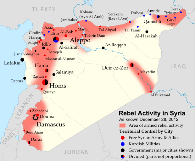
 In recent months, Syria's rebels have continued to tip the balance of the country's civil war toward their favor, with various local victories and a few further extensions of their territorial control. Below is the updated conflict map, plus a summary of recent territorial changes.

Map of rebel activity and control in Syria's Civil War (Free Syrian Army, Kurdish groups, and others), updated for December 2012. Includes recent locations of conflict, including Salqin, Harem, Beer Ajam, Tishrin Dam, and Ras al-Ayn.
Activity and cities held by rebels and other groups in Syria, updated for December 2012. Map by Evan Centanni, starting from this blank map by German Wikipedia user NordNordWest. License: CC BY-SA

Thursday, December 20, 2012

Kosovo Now Recogized by Half of U.N. (97/193)

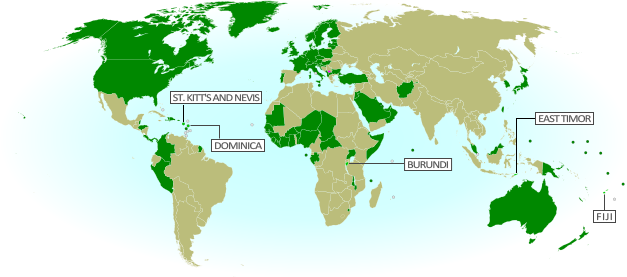
Map of countries that recognize the Republic of Kosovo as an independent state, updated for December 2012 with most recent additions highlighted
Countries recognizing the Republic of Kosovo in green, with the five most recent additions to the list labelled. Kosovo in magenta. Map by Evan Centanni, modified from public domain graphic (source).

Thursday, December 13, 2012

Somalia: Al Shabaab Map Update (Dec. 2012)

There are newer versions of this map available. To see them, view all Somalia articles on PolGeoNow.

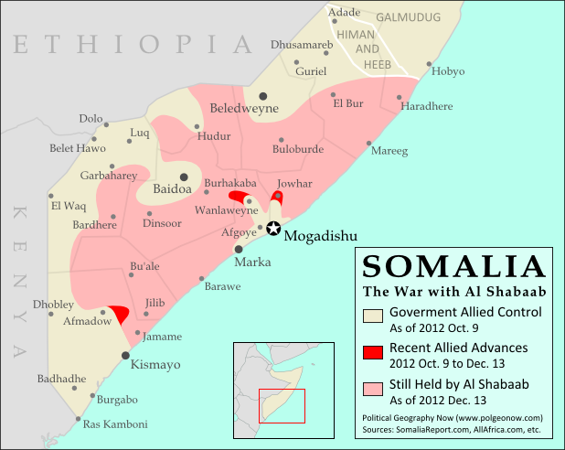
Al Shabaab, Somalia's local branch of Al Qaeda, has continued to gradually lose territory since government-allied forces captured its main stronghold two months ago. As a follow-up to our October feature on the two-year retreat of Al Shabaab, we now present the latest changes to the map of control in southern Somalia.

Map of Al Shabaab control in southern Somalia as of December 2012, highlighting recent advances by government and African Union troops since the capture of key port city Kismayo. Includes the December capture of Jowhar by Ugandan AU forces.
Southern Somalia: recent government-allied advances against Al Shabaab. Original map by Evan Centanni. Incorporates elements from this blank map by Eric Gaba and this locator map by TheEmirr. (license: CC BY-SA).


Slow Progress Against Al Shabaab
Somalia's Islamic extremist militia, Al Shabaab, was greatly weakened when its biggest port and de facto capital of Kismayo was taken by government-allied African Union (AU) forces in October (See: The Retreat of Al Shabaab). However, it still controls a significant amount of territory, and the Somali and AU forces' advance has been slow, with their first major territorial gain acheived only this past weekend.

Thursday, December 6, 2012

Is Palestine Really a Country?

(Keep up with changes to Palestine's situation: view all Palestine updates.)

Palestine is now recognized as a country by both the U.N. and a majority of its members, but many  have questioned whether this new-found status reflects the truth on the ground. Is Palestine really an independent country, or is this a political fantasy concocted by supporters in the U.N.?

The Olso Accords divided the Palestinian territories into three areas of control (see article for explanation). Map by Evan Centanni. Sources: Natural Earth, B'Tselem, U.N. OCHA oPt.
What is a "sovereign state"?
By the most common definition, a "state" has to have:
  1. A government
  2. A defined territory
  3. A permanent population
  4. The ability to conduct foreign relations with other states
This definition is called the "declarative theory of statehood", and was formalized in the Montevideo Convention of 1933. To be a "sovereign" state (i.e. an independent country), it's also important that the government answers to no other country, and that the territory and population are actually under the government's control.

A prospective country that fits these criteria is described by geographers as a de facto sovereign state, even if it's not recognized by the international community (de facto is Latin for "in actual fact").